Our Vimeo Channel: The Goldseekers
Our U Tube Channel: TheGoldseekers

Bear Creek Falls
Bear Creek Falls is in British Columbia's Glacier National Park The falls are found along Connaught Creek where it descends out of a valley flowing down from Rogers Pass to join the Beaver River valley. The falls consist of at least three steps, but because of how the falls twist down its gorge, less than half of the overall height of the falls can be seen. The visible portion of the falls drop an estimated 80 feet. It is hard to tell the overall height of the falls due to the overspray, but the total drop is closer to about 180 feet in all.
Connaught Creek drains from a basin covering about 19 square miles, and is partially fed by the Rogers and Swiss Glaciers. The entire drainage is situated above the 3000 foot elevation, and will receive heavy snow pack in the winter months. Stream flow is very consistent and considerably strong in the spring and early summer months, often ejecting such a volume of mist from the falls that getting close to its base becomes difficult due to the blinding spray.
This waterfall was originally known as Abbott Falls, a name that dates back to at least 1891 when surveys of the Rogers Pass area were surveying for the Canadian Pacific Railway. The falls are sometimes mislabeled as either Bear Falls or Beaver Falls. Connaught Creek was formerly known as Bear Creek, and when the name of the creek was changed, the name of the falls was not updated. Beaver has at times drifted over to the falls from the nearby Beaver River, but this has never been a correct name as far as we have been able to tell.
The trailhead for Bear Creek Falls is found at the end of a dead-end road that branches off of the Trans-Canada Highway 6 miles east of Rogers Pass - watch for green signs indicating the falls. From the parking at the end of the road, the trail descends fairly steeply down to Connaught Creek and ends at the base of the falls.

Video of Bear Creek Falls
Sutherland Falls is along Highway 23 between Revelstoke and the Shelter Bay Ferry terminal. The falls drop about 45 feet at the bottom of a canyon near the mouth of Blanket Creek, a glacier-fed stream that ends at Upper Arrow Lake, a man-made reservoir on the Columbia River. It's a short walk from the day use area of Blanket Creek Provincial Park.
Southerland Falls
Vedio of summerland Falls
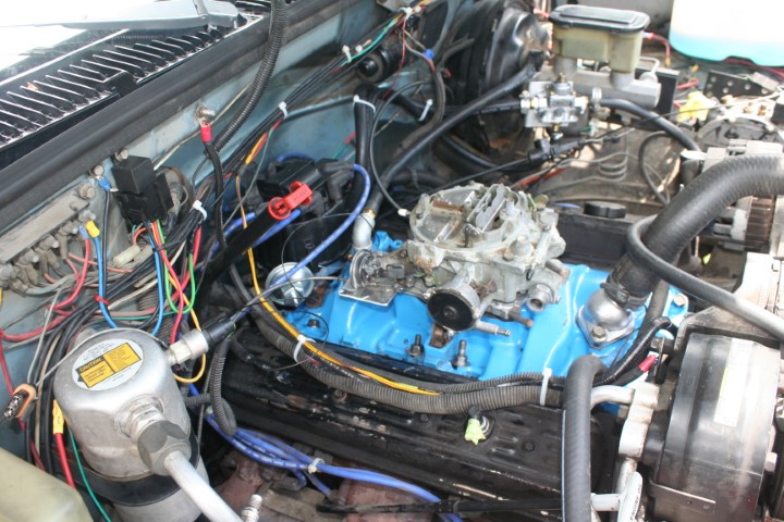
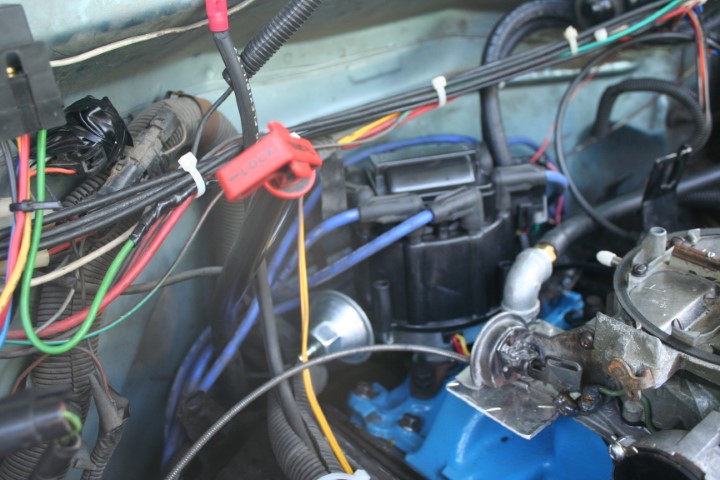
Converting TBI to carb
Watch a video on how I converted a TBI to carb

BX Falls
BX Falls is a small waterfall just northeast of Vernon, British Columbia. It is located just downstream from Tillicum Road's crossing of BX Creek. The falls are located in between Tillicum Road and Star Road, both of which branch off Silverstar Road. A trail runs between the two roads and a short side trail descends into the canyon off the main trail and allows visitors to see the falls up close.
The falls are along a steep canyon along BX Creek just below where the creek passes under Tillicum Road. The creek flows into the canyon, flows through a couple of small pools before cascading 30 ft into a small clearing in the canyon below. The falls are not all that steep, so in the winter when the falls freeze over and there is enough snow that piles on top of the ice on the falls it is actually quite easy to climb up the falls without any special equipment.
A video on BX Falls
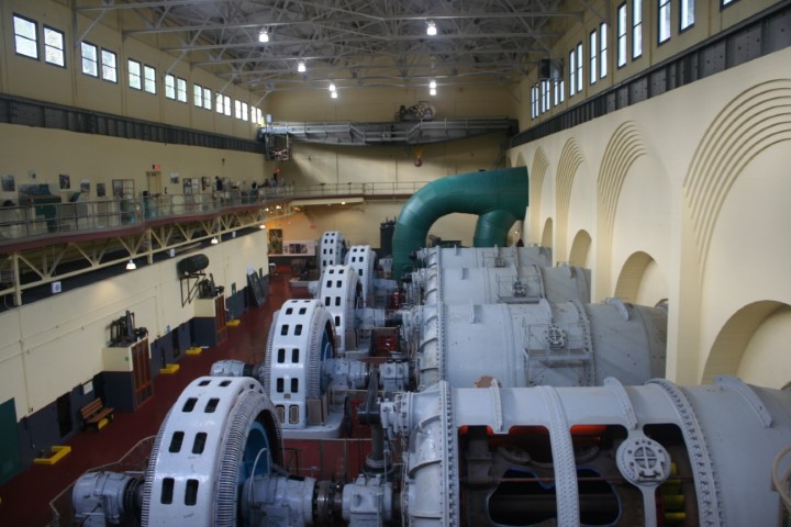
Stave Lake Power Plant video
Stave Lake Power Plant
The Stave Lake Power Plant is located in Mission, British Columbia. This former generating facility is a National Historic Site of Canada filled with archival photos, artifacts and the original mechanical and electrical components which helped power the province. Take a walk through a 100-year-old powerhouse and enjoy the historical displays, electricity demonstrations and many interactive exhibits
The Stave Lake Power Plant is located in Mission, British Columbia. This former generating facility is a National Historic Site of Canada filled with archival photos, artifacts and the original mechanical and electrical components which helped power the province. Take a walk through a 100-year-old powerhouse and enjoy the historical displays, electricity demonstrations and many interactive exhibits